
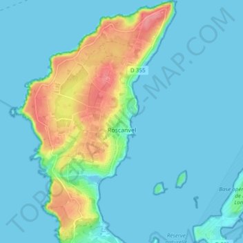
Roscanvel topographic map
Interactive map
Click on the map to display elevation.
About this map
Name: Roscanvel topographic map, elevation, terrain.
Average elevation: 15 m
Minimum elevation: -1 m
Maximum elevation: 76 m
Other topographic maps
Click on a map to view its topography, its elevation and its terrain.
Moulin de Bel Air
Frankrijk > Bretagne > Finistère > Brélès
Moulin de Bel Air, Brélès, Brest, Finistère, Bretagne, Metropolitaans Frankrijk, 29810, Frankrijk
Average elevation: 40 m
Châteauneuf-du-Faou
Frankrijk > Bretagne > Finistère > Châteauneuf-du-Faou
Châteauneuf-du-Faou, Châteaulin, Finistère, Bretagne, Metropolitaans Frankrijk, 29520, Frankrijk
Average elevation: 115 m