
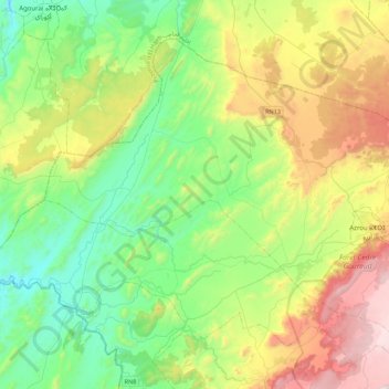
Tigrigra topographic map
Interactive map
Click on the map to display elevation.
About this map
Name: Tigrigra topographic map, elevation, terrain.
Average elevation: 1,156 m
Minimum elevation: 750 m
Maximum elevation: 2,004 m
Other topographic maps
Click on a map to view its topography, its elevation and its terrain.
Bekrit
Maroc > cercle d'Azrou > Sidi El Makhfi
Bekrit, Sidi El Makhfi, caïdat Sidi Addi, cercle d'Azrou, Province d'Ifrane, Fès-Meknès, Maroc
Average elevation: 1,843 m
Ifrane forêt
Maroc > cercle d'Azrou > Ben Smim
Ifrane forêt, RN8, Ben Smim, caïdat de Irklaouen, cercle d'Azrou, Province d'Ifrane, Fès-Meknès, 53002, Maroc
Average elevation: 1,637 m
Aïn Leuh
Aïn Leuh, caïdat de Ain Leuh, cercle d'Azrou, Province d'Ifrane, Fès-Meknès, 53052, Maroc
Average elevation: 1,531 m
Dayet Aaoua
Maroc > cercle d'Azrou > Dayat Aoua > Lahrahir Dayat Aoua
Dayet Aaoua, Lahrahir Dayat Aoua, Dayat Aoua, caïdat de Dayat Aoua, cercle d'Azrou, Province d'Ifrane, Fès-Meknès, Maroc
Average elevation: 1,518 m
Zaouiat Ifrane
Maroc > cercle d'Azrou > Oued Ifrane
Zaouiat Ifrane, P7210, Zaouia Oued Ifrane, Oued Ifrane, caïdat de Oued Ifrane, cercle d'Azrou, Province d'Ifrane, Fès-Meknès, 54452, Maroc
Average elevation: 1,455 m
Oued Ifrane
Maroc > cercle d'Azrou > Oued Ifrane
Oued Ifrane, caïdat de Oued Ifrane, cercle d'Azrou, Province d'Ifrane, Fès-Meknès, Maroc
Average elevation: 1,665 m
Timhadit
Timhadit, caïdat de Timahdite, cercle d'Azrou, Province d'Ifrane, Fès-Meknès, Maroc
Average elevation: 1,902 m
Sidi Addi
Maroc > cercle d'Azrou > Sidi El Makhfi
Sidi Addi, Sidi El Makhfi, caïdat Sidi Addi, cercle d'Azrou, Province d'Ifrane, Fès-Meknès, 53102, Maroc
Average elevation: 1,116 m
Ben Smim
Ben Smim, caïdat de Irklaouen, cercle d'Azrou, Province d'Ifrane, Fès-Meknès, Maroc
Average elevation: 1,569 m