
Orakei topographic map
Interactive map
Click on the map to display elevation.
About this map
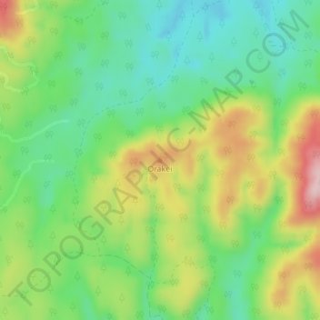
Name: Orakei topographic map, elevation, terrain.
Location: Orakei, Whakatane District, Bay of Plenty, New Zealand (-38.58636 176.70073 -38.58626 176.70083)
Average elevation: 455 m
Minimum elevation: 360 m
Maximum elevation: 609 m
Other topographic maps
Click on a map to view its topography, its elevation and its terrain.
Galatea
New Zealand > Bay of Plenty > Whakatane District
Galatea, Whakatāne District, Bay of Plenty, New Zealand
Average elevation: 174 m
Edgecumbe
New Zealand > Bay of Plenty > Whakatane District
Edgecumbe, Whakatāne District, Bay of Plenty, 3193, New Zealand
Average elevation: 10 m
Whakatāne
New Zealand > Bay of Plenty > Whakatane District
Whakatāne, Whakatāne District, Bay of Plenty, 3158, New Zealand
Average elevation: 30 m
Thornton
New Zealand > Bay of Plenty > Whakatane District
Thornton, Whakatāne District, Bay of Plenty, New Zealand
Average elevation: 5 m
Lake Tahuna
New Zealand > Bay of Plenty > Whakatane District
Lake Tahuna, Whakatāne District, Bay of Plenty, New Zealand
Average elevation: 38 m
Pikowai
New Zealand > Bay of Plenty > Whakatane District
Pikowai, Whakatāne District, Bay of Plenty, New Zealand
Average elevation: 33 m
Tokanui
New Zealand > Bay of Plenty > Whakatane District
Tokanui, Whakatāne District, Bay of Plenty, New Zealand
Average elevation: 349 m
Ōhope
New Zealand > Bay of Plenty > Whakatane District
Ōhope, Whakatāne District, Bay of Plenty, 3121, New Zealand
Average elevation: 40 m
Manawahe
New Zealand > Bay of Plenty > Whakatane District
Manawahe, Whakatane District, Bay of Plenty, New Zealand
Average elevation: 332 m
Tiritiri
New Zealand > Bay of Plenty > Whakatane District
Tiritiri, Whakatane District, Bay of Plenty, New Zealand
Average elevation: 506 m
Port Ohope
New Zealand > Bay of Plenty > Whakatane District
Port Ohope, Whakatane District, Bay of Plenty, New Zealand
Average elevation: 1 m
Matahi
New Zealand > Bay of Plenty > Whakatane District > Matahi
Matahi, Whakatane District, Bay of Plenty, New Zealand
Average elevation: 275 m
Matatā
New Zealand > Bay of Plenty > Whakatane District
Matatā, Whakatāne District, Bay of Plenty, 3194, New Zealand
Average elevation: 52 m
Te Teko
New Zealand > Bay of Plenty > Whakatane District
Te Teko, Whakatāne District, Bay of Plenty, New Zealand
Average elevation: 143 m
Coastlands
New Zealand > Bay of Plenty > Whakatane District > Whakatane
Coastlands, Whakatāne, Whakatāne District, Bay of Plenty, 3191, New Zealand
Average elevation: 5 m
Nukuhou River
New Zealand > Bay of Plenty > Whakatane District
Nukuhou River, Whakatāne District, Bay of Plenty, New Zealand
Average elevation: 99 m