
La Costière topographic map
Interactive map
Click on the map to display elevation.
About this map
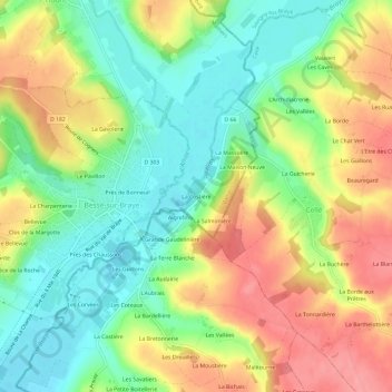
Name: La Costière topographic map, elevation, terrain.
Average elevation: 104 m
Minimum elevation: 64 m
Maximum elevation: 153 m
Other topographic maps
Click on a map to view its topography, its elevation and its terrain.
Château de Courtanvaux
France > Pays de la Loire > Sarthe > Bessé-sur-Braye
Château de Courtanvaux, Route de Vancé, La Baraudière, Bessé-sur-Braye, Mamers, Sarthe, Pays de la Loire, France métropolitaine, 72310, France
Average elevation: 113 m