
Manching topographic map
Interactive map
Click on the map to display elevation.
About this map
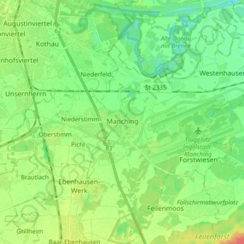
Name: Manching topographic map, elevation, terrain.
Average elevation: 367 m
Minimum elevation: 350 m
Maximum elevation: 397 m
Es gab 2018 nach der amtlichen Statistik 7582 sozialversicherungspflichtig Beschäftigte am Arbeitsort. Sozialversicherungspflichtig Beschäftigte am Wohnort gab es insgesamt 5835, so dass die Zahl der Einpendler um 1747 höher war als die Zahl der Auspendler. 2016 gab es 53 landwirtschaftliche Betriebe, die eine Fläche von 2312 Hektar bewirtschafteten.
Other topographic maps
Click on a map to view its topography, its elevation and its terrain.
Straßhöfe
Deutschland > Bayern > Landkreis Pfaffenhofen an der Ilm > Rohrbach
Straßhöfe, Rohrbach, Landkreis Pfaffenhofen an der Ilm, Bayern, 85296, Deutschland
Average elevation: 426 m