
Village of Ossining topographic map
Interactive map
Click on the map to display elevation.
About this map
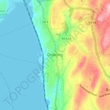
Name: Village of Ossining topographic map, elevation, terrain.
Average elevation: 61 m
Minimum elevation: -2 m
Maximum elevation: 189 m
Other topographic maps
Click on a map to view its topography, its elevation and its terrain.
Yorktown Heights
United States > New York > Westchester County > Town of Yorktown
Yorktown Heights, Town of Yorktown, Westchester County, New York, United States
Average elevation: 159 m
Village of Tuckahoe
United States > New York > Westchester County > Town of Eastchester
Village of Tuckahoe, Town of Eastchester, Westchester County, New York, United States
Average elevation: 57 m
Village of Mamaroneck
United States > New York > Westchester County
Village of Mamaroneck, Town of Mamaroneck, Westchester County, New York, 10543, United States
Average elevation: 15 m
Waccabuc
United States > New York > Westchester County > Town of Lewisboro
Waccabuc, Town of Lewisboro, Westchester County, New York, 10597, United States
Average elevation: 183 m
Heath Ridge
United States > New York > Westchester County > Village of Scarsdale
Heath Ridge, Village of Scarsdale, Westchester County, New York, 10583, United States
Average elevation: 66 m
Cecil Park
United States > New York > Westchester County > City of Yonkers
Cecil Park, City of Yonkers, Westchester County, New York, 10707, United States
Average elevation: 70 m
Village of Dobbs Ferry
United States > New York > Westchester County
Village of Dobbs Ferry, Town of Greenburgh, Westchester County, New York, United States
Average elevation: 54 m
Wilmot Woods
United States > New York > Westchester County > City of New Rochelle
Wilmot Woods, City of New Rochelle, Westchester County, New York, 10583, United States
Average elevation: 70 m
Orienta
United States > New York > Westchester County > Village of Mamaroneck
Orienta, Village of Mamaroneck, Town of Mamaroneck, Westchester County, New York, 10543, United States
Average elevation: 7 m
Forest Knolls
United States > New York > Westchester County > City of New Rochelle
Forest Knolls, City of New Rochelle, Westchester County, New York, 10804, United States
Average elevation: 34 m
Village of Larchmont
United States > New York > Westchester County > Town of Mamaroneck
Village of Larchmont, Town of Mamaroneck, Westchester County, New York, 10538, United States
Average elevation: 8 m
Village of Tarrytown
United States > New York > Westchester County
Village of Tarrytown, Town of Greenburgh, Westchester County, New York, 10591, United States
Average elevation: 54 m
Town of Somers
United States > New York > Westchester County
Town of Somers, Westchester County, New York, United States
Average elevation: 125 m
Katonah
United States > New York > Westchester County > Town of Bedford
Katonah, Town of Bedford, Westchester County, New York, United States
Average elevation: 94 m
Cross River
United States > New York > Westchester County > Town of Lewisboro
Cross River, Town of Lewisboro, Westchester County, New York, 10518, United States
Average elevation: 155 m
Village of Scarsdale
United States > New York > Westchester County
Village of Scarsdale, Westchester County, New York, 10583, United States
Average elevation: 76 m
Armonk
United States > New York > Westchester County
Armonk, Town of North Castle, Westchester County, New York, 10504, United States
Average elevation: 156 m
Town/Village of Harrison
United States > New York > Westchester County
Town/Village of Harrison, Westchester County, New York, United States
Average elevation: 63 m
Village/Town of Mount Kisco
United States > New York > Westchester County
Village/Town of Mount Kisco, Westchester County, New York, 10549, United States
Average elevation: 121 m
Town of New Castle
United States > New York > Westchester County
Town of New Castle, Westchester County, New York, United States
Average elevation: 133 m
Town of Pound Ridge
United States > New York > Westchester County
Town of Pound Ridge, Westchester County, New York, 10576, United States
Average elevation: 156 m
Village of Rye Brook
United States > New York > Westchester County
Village of Rye Brook, Town of Rye, Westchester County, New York, United States
Average elevation: 65 m
Town of Mount Pleasant
United States > New York > Westchester County > Town of Mount Pleasant
Town of Mount Pleasant, Westchester County, New York, United States
Average elevation: 116 m
Village of Croton-on-Hudson
United States > New York > Westchester County
Village of Croton-on-Hudson, Town of Cortlandt, Westchester County, New York, 10520, United States
Average elevation: 42 m
Beechmont
United States > New York > Westchester County > City of New Rochelle > Beechmont
Beechmont, City of New Rochelle, Westchester County, New York, 10801, United States
Average elevation: 31 m
Village of Pleasantville
United States > New York > Westchester County > Town of Mount Pleasant > Village of Pleasantville
Village of Pleasantville, Town of Mount Pleasant, Westchester County, New York, 10570, United States
Average elevation: 124 m
Thornwood
United States > New York > Westchester County > Town of Mount Pleasant > Thornwood
Thornwood, Town of Mount Pleasant, Westchester County, New York, 10594, United States
Average elevation: 121 m
Town of Greenburgh
United States > New York > Westchester County > Town of Greenburgh
Town of Greenburgh, Westchester County, New York, United States
Average elevation: 67 m
Parkside
United States > New York > Westchester County > City of Mount Vernon > Parkside
Parkside, City of Mount Vernon, Westchester County, New York, 10553, United States
Average elevation: 27 m
Chappaqua
United States > New York > Westchester County > Town of New Castle
Chappaqua, Town of New Castle, Westchester County, New York, United States
Average elevation: 145 m
Elmsford
United States > New York > Westchester County > Town of Greenburgh > Elmsford
Elmsford, Town of Greenburgh, Westchester County, New York, 10523, United States
Average elevation: 88 m
Colonial Acres
United States > New York > Westchester County > Scarsdale > Colonial Acres
Colonial Acres, Scarsdale, Westchester County, New York, 10583:10804, United States
Average elevation: 55 m
Town of Cortlandt
United States > New York > Westchester County > Town of Cortlandt
Town of Cortlandt, Westchester County, New York, United States
Average elevation: 94 m
City of Rye
United States > New York > Westchester County
City of Rye, Westchester County, New York, United States
Average elevation: 9 m
City of New Rochelle
United States > New York > Westchester County
City of New Rochelle, Westchester County, New York, United States
Average elevation: 31 m
City of Yonkers
United States > New York > Westchester County
City of Yonkers, Westchester County, New York, United States
Average elevation: 58 m