
Kunigal topographic map
Interactive map
Click on the map to display elevation.
About this map
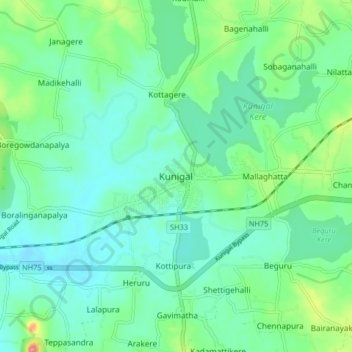
Name: Kunigal topographic map, elevation, terrain.
Average elevation: 775 m
Minimum elevation: 751 m
Maximum elevation: 850 m
Kunigal is located at 13°01′N 77°02′E / 13.02°N 77.03°E / 13.02; 77.03. It has an average elevation of 773 metres (2536 feet). It is situated on the National Highway 48 ( NH-48 ) connecting Bangalore and Mangalore and State Highway 33 connecting Tumakuru and Madduru. Recently opened Hassan-Bangalore railway line transverses through Kunigal.
Other topographic maps
Click on a map to view its topography, its elevation and its terrain.
Sugganahalli
India > Karnataka > Kunigal taluk
Sugganahalli, Kunigal taluk, Tumakuru District, Karnataka, India
Average elevation: 676 m
Ujjani
India > Karnataka > Kunigal taluk
Ujjani, Kunigal taluk, Tumkur district, Karnataka, 572123, India
Average elevation: 717 m