
Caledon topographic map
Click on the map to display elevation.
About this map
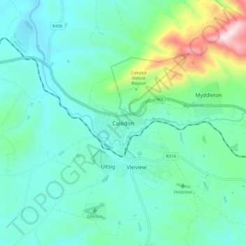
Name: Caledon topographic map, elevation, terrain.
Average elevation: 311 m
Minimum elevation: 156 m
Maximum elevation: 920 m
Other topographic maps
Click on a map to view its topography, its elevation and its terrain.
Theewaterskloof Ward 9
South Africa > Overberg District Municipality > Theewaterskloof Local Municipality
Average elevation: 564 m