
Thank you for supporting this site ❤️
Make a donation
Make a donation
Shemokmedi topographic map
Click on the map to display elevation.
Thank you for supporting this site ❤️
Make a donation
Make a donation
Shemokmedi
Shemokmedi (Georgian: შემოქმედი) is a village in the Ozurgeti Municipality, Guria, Georgia. It is located in western Georgia, on the Bzhuzhi river, at elevation of 190 m above sea level, 7 km east of the city of Ozurgeti. The village is home to the late medieval Shemokmedi Monastery.
Thank you for supporting this site ❤️
Make a donation
Make a donation
About this map
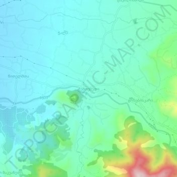
Name: Shemokmedi topographic map, elevation, terrain.
Location: Shemokmedi, Ozurgeti Municipality, Guria, 3523, Georgia (41.88934 42.04690 41.92934 42.08690)
Average elevation: 181 m
Minimum elevation: 111 m
Maximum elevation: 469 m
Thank you for supporting this site ❤️
Make a donation
Make a donation
Other topographic maps
Click on a map to view its topography, its elevation and its terrain.