
Make a donation
Northern Mindanao topographic map
Click on the map to display elevation.
Make a donation
Northern Mindanao
Northern Mindanao has a total land area of 2,049,602 hectares (5,064,680 acres). More than 60% of Northern Mindanao's total land area are classified as forest land. Its seas abound with fish and other marine products. The abundant vegetation, natural springs and high elevation contribute to the region's cool, mild and invigorating climate.
Make a donation
About this map
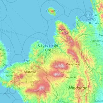
Name: Northern Mindanao topographic map, elevation, terrain.
Location: Northern Mindanao, Philippines (7.40326 123.54032 9.39311 125.44932)
Average elevation: 356 m
Minimum elevation: 0 m
Maximum elevation: 2,783 m
Make a donation
Other topographic maps
Click on a map to view its topography, its elevation and its terrain.
Antipolo
Its higher elevation than that of Metro Manila affords it a scenic view of the metropolis, especially at night. Its locally grown mangoes and cashews are popular among tourists, as well as suman – a local delicacy made out of glutinous rice. The Hinulugang Taktak National Park, which was once a popular…
Average elevation: 125 m
Make a donation
Make a donation
Make a donation
Make a donation
Make a donation
Muntinlupa
There are three plausible origins of the name of the city: First, is its association with the thin topsoil in the area; second, residents, purportedly replying to a question by Spaniards in the 16th century what the name of their place was, said “Monte sa Lupa”—apparently mistaking the question for what…
Average elevation: 41 m
Make a donation
Make a donation