
Bornes topographic map
Click on the map to display elevation.
About this map
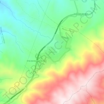
Name: Bornes topographic map, elevation, terrain.
Location: Bornes, Macedo de Cavaleiros, Distrito de Bragança, Portugal (41.43984 -7.02403 41.47984 -6.98403)
Average elevation: 790 m
Minimum elevation: 540 m
Maximum elevation: 1,129 m
Other topographic maps
Click on a map to view its topography, its elevation and its terrain.
Ala e Vilarinho do Monte
Portugal > Distrito de Bragança > Macedo de Cavaleiros
Average elevation: 600 m
Parque do Santuário de Santo Ambrósio
Portugal > Distrito de Bragança > Macedo de Cavaleiros > Vale da Porca
Average elevation: 573 m
Paisagem Protegida da Albufeira do Azibo
Portugal > Distrito de Bragança > Macedo de Cavaleiros
Average elevation: 634 m