
Al Hajrah topographic map
Interactive map
Click on the map to display elevation.
About this map
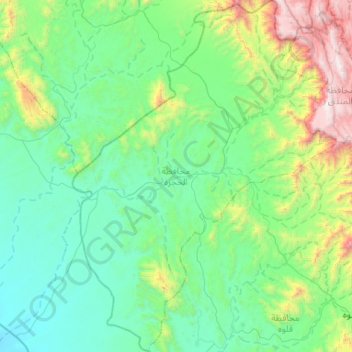
Name: Al Hajrah topographic map, elevation, terrain.
Location: Al Hajrah, Al-Bahah Province, Saudi Arabia (19.88724 40.83591 20.38029 41.23074)
Average elevation: 481 m
Minimum elevation: 33 m
Maximum elevation: 2,342 m
Other topographic maps
Click on a map to view its topography, its elevation and its terrain.
Biljurashi
Saudi Arabia > Al-Bahah Province
Biljurashi, Al-Bahah Province, Saudi Arabia
Average elevation: 1,528 m