
Thank you for supporting this site ❤️
Make a donation
Make a donation
Mount Mellick topographic map
Click on the map to display elevation.
Thank you for supporting this site ❤️
Make a donation
Make a donation
About this map
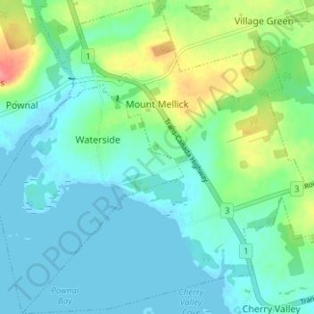
Name: Mount Mellick topographic map, elevation, terrain.
Location: Mount Mellick, Queens County, Prince Edward Island, Canada (46.17366 -62.97287 46.21690 -62.91649)
Average elevation: 18 m
Minimum elevation: -2 m
Maximum elevation: 72 m
Thank you for supporting this site ❤️
Make a donation
Make a donation
Other topographic maps
Click on a map to view its topography, its elevation and its terrain.
French Village
Canada > Prince Edward Island > Queens County > Savage Harbour, Queen's County
Average elevation: 12 m