
Thank you for supporting this site ❤️
Make a donation
Make a donation
Tharon Plage topographic map
Click on the map to display elevation.
Thank you for supporting this site ❤️
Make a donation
Make a donation
About this map
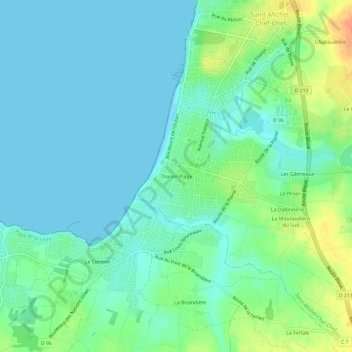
Name: Tharon Plage topographic map, elevation, terrain.
Average elevation: 11 m
Minimum elevation: -1 m
Maximum elevation: 39 m
Thank you for supporting this site ❤️
Make a donation
Make a donation
Other topographic maps
Click on a map to view its topography, its elevation and its terrain.
44730
France > Pays de la Loire > Loire-Atlantique > Saint-Michel-Chef-Chef > La Hervière
Average elevation: 32 m