
Make a donation
Tabuk Province topographic map
Click on the map to display elevation.
Make a donation
About this map
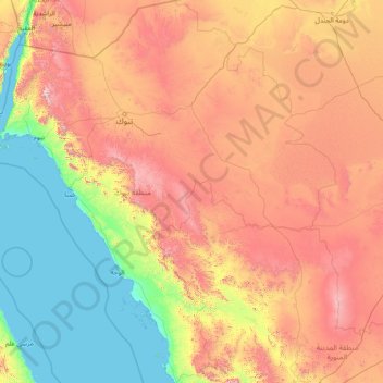
Name: Tabuk Province topographic map, elevation, terrain.
Location: Tabuk Province, Saudi Arabia (24.56184 34.49441 29.97559 39.94176)
Average elevation: 695 m
Minimum elevation: 0 m
Maximum elevation: 2,482 m
Make a donation
Other topographic maps
Click on a map to view its topography, its elevation and its terrain.
Make a donation
Abha
Abha is located in the southern region of Asir at an elevation of about 2,270 metres (7,450 feet) above sea level. Abha lies on the western edge of Mount Al-Hijaz, near Jabal Sawda, the highest peak in Saudi Arabia. Treating the Asir Mountains as part of the Sarawat, the landscape is otherwise dominated by the…
Average elevation: 1,994 m
Make a donation
Neom
On 3 March 2022, Saudi Crown Prince Mohammed bin Salman launched the Trojena project, which will be the first major outdoor skiing destination in the Arabian Peninsula. It will be located in Saudi Arabia's highest mountain range, about 50 kilometres (31 mi) from the Gulf of Aqaba coast, with elevations ranging…
Average elevation: 52 m