
Gambassi Terme topographic map
Interactive map
Click on the map to display elevation.
About this map
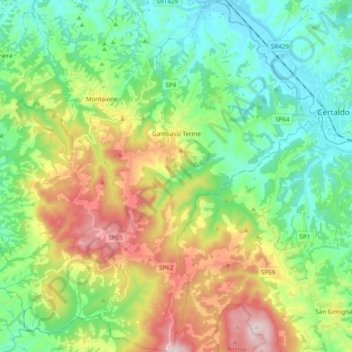
Name: Gambassi Terme topographic map, elevation, terrain.
Location: Gambassi Terme, Metropolitan City of Florence, Tuscany, Italy (43.45150 10.85113 43.59212 11.03426)
Average elevation: 240 m
Minimum elevation: 51 m
Maximum elevation: 626 m
Other topographic maps
Click on a map to view its topography, its elevation and its terrain.
Arno
Italy > Tuscany > Metropolitan City of Florence > Florence
Arno, Quartiere 1, Florence, Metropolitan City of Florence, Tuscany, Italy
Average elevation: 71 m
Florence
Italy > Tuscany > Metropolitan City of Florence > Florence
Florence, Metropolitan City of Florence, Tuscany, Italy
Average elevation: 142 m