
Thank you for supporting this site ❤️
Make a donation
Make a donation
Tinduff topographic map
Click on the map to display elevation.
Thank you for supporting this site ❤️
Make a donation
Make a donation
About this map
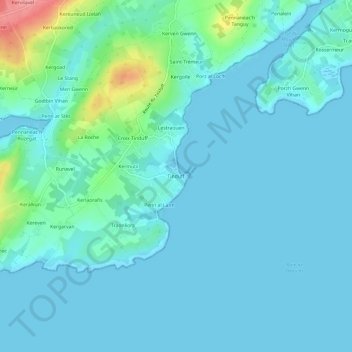
Name: Tinduff topographic map, elevation, terrain.
Average elevation: 14 m
Minimum elevation: -1 m
Maximum elevation: 99 m
Thank you for supporting this site ❤️
Make a donation
Make a donation
Other topographic maps
Click on a map to view its topography, its elevation and its terrain.
Grève de Porsguen
France > Bretagne > Finistère > Plougastel-Daoulas > Porzh Gwenn Vihan
Average elevation: 8 m