
Ettiswil topographic map
Interactive map
Click on the map to display elevation.
About this map
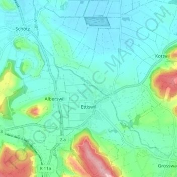
Name: Ettiswil topographic map, elevation, terrain.
Location: Ettiswil, Luzern, Schweiz (47.12910 8.00152 47.17761 8.06130)
Average elevation: 536 m
Minimum elevation: 496 m
Maximum elevation: 687 m
Other topographic maps
Click on a map to view its topography, its elevation and its terrain.
Tschädigen
Tschädigen, Meggen, Luzern, 6045, Schweiz
Average elevation: 534 m
Eigenthal
Schweiz > Luzern > Schwarzenberg
Eigenthal, Schwarzenberg, Luzern, 6013, Schweiz
Average elevation: 991 m
Rigi Kaltbad
Rigi Kaltbad, Weggis, Luzern, 6356, Schweiz
Average elevation: 1,099 m
Hergiswil bei Willisau
Hergiswil bei Willisau, Luzern, 6133, Schweiz
Average elevation: 864 m
Kastanienbaum
Kastanienbaum, Horw, Luzern, 6047, Schweiz
Average elevation: 457 m