
Thank you for supporting this site ❤️
Make a donation
Make a donation
Victor Khanye Ward 9 topographic map
Click on the map to display elevation.
Thank you for supporting this site ❤️
Make a donation
Make a donation
About this map
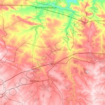
Name: Victor Khanye Ward 9 topographic map, elevation, terrain.
Average elevation: 1,526 m
Minimum elevation: 1,352 m
Maximum elevation: 1,650 m
Thank you for supporting this site ❤️
Make a donation
Make a donation
Other topographic maps
Click on a map to view its topography, its elevation and its terrain.
Delmas
South Africa > Mpumalanga > Nkangala > Victor Khanye Local Municipality
Average elevation: 1,566 m
Wilge River
South Africa > Mpumalanga > Nkangala > Victor Khanye Local Municipality
Average elevation: 1,541 m
Wilge River
South Africa > Mpumalanga > Nkangala > Victor Khanye Local Municipality
Average elevation: 1,530 m