
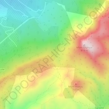
Bergerie du Perdu topographic map
Interactive map
Click on the map to display elevation.
About this map
Name: Bergerie du Perdu topographic map, elevation, terrain.
Average elevation: 519 m
Minimum elevation: 283 m
Maximum elevation: 812 m
Other topographic maps
Click on a map to view its topography, its elevation and its terrain.
Mont Olympe
France > Provence-Alpes-Côte d'Azur > Bouches-du-Rhône > Trets
Mont Olympe, Trets, Aix-en-Provence, Bouches-du-Rhône, Provence-Alpes-Côte d'Azur, France métropolitaine, 13530, France
Average elevation: 553 m
Cabassude
France > Provence-Alpes-Côte d'Azur > Bouches-du-Rhône > Trets
Cabassude, Trets, Aix-en-Provence, Bouches-du-Rhône, Provence-Alpes-Côte d'Azur, France métropolitaine, 13530, France
Average elevation: 450 m
Pas de la Couelle
France > Provence-Alpes-Côte d'Azur > Bouches-du-Rhône > Trets
Pas de la Couelle, Trets, Aix-en-Provence, Bouches-du-Rhône, Provence-Alpes-Côte d'Azur, France métropolitaine, 13530, France
Average elevation: 473 m
Kirbon
France > Provence-Alpes-Côte d'Azur > Bouches-du-Rhône > Trets
Kirbon, Trets, Aix-en-Provence, Bouches-du-Rhône, Provence-Alpes-Côte d'Azur, France métropolitaine, 13530, France
Average elevation: 442 m