
Thank you for supporting this site ❤️
Make a donation
Make a donation
Setsoto Ward 3 topographic map
Click on the map to display elevation.
Thank you for supporting this site ❤️
Make a donation
Make a donation
About this map
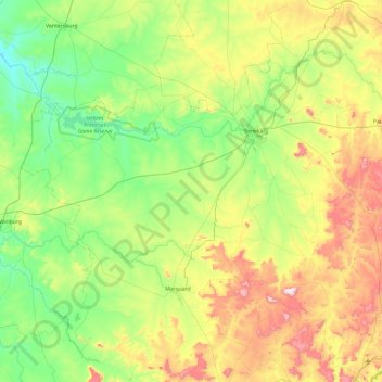
Name: Setsoto Ward 3 topographic map, elevation, terrain.
Average elevation: 1,516 m
Minimum elevation: 1,310 m
Maximum elevation: 1,994 m
Thank you for supporting this site ❤️
Make a donation
Make a donation
Other topographic maps
Click on a map to view its topography, its elevation and its terrain.
Aldam
South Africa > Free State > Thabo Mofutsanyana District Municipality > Setsoto Local Municipality
Average elevation: 1,372 m