
Thank you for supporting this site ❤️
Make a donation
Make a donation
Dallas Plantation topographic map
Click on the map to display elevation.
Thank you for supporting this site ❤️
Make a donation
Make a donation
About this map
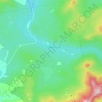
Name: Dallas Plantation topographic map, elevation, terrain.
Location: Dallas Plantation, Franklin County, Maine, United States (44.93991 -70.64982 45.04654 -70.50366)
Average elevation: 543 m
Minimum elevation: 420 m
Maximum elevation: 884 m
Thank you for supporting this site ❤️
Make a donation
Make a donation
Other topographic maps
Click on a map to view its topography, its elevation and its terrain.