
Luangwa District topographic map
Interactive map
Click on the map to display elevation.
About this map
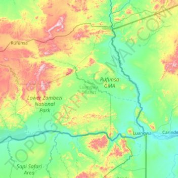
Name: Luangwa District topographic map, elevation, terrain.
Location: Luangwa District, Lusaka Province, Zambia (-15.72043 29.31199 -14.99737 30.42080)
Average elevation: 584 m
Minimum elevation: 320 m
Maximum elevation: 1,487 m
Other topographic maps
Click on a map to view its topography, its elevation and its terrain.
Munali
Zambia > Lusaka Province > Munali
Munali, Lusaka Province, 38836, Zambia
Average elevation: 1,248 m
Kafue
Kafue, Kafue District, Lusaka Province, Zambia
Average elevation: 1,028 m