
Fouvent-Saint-Andoche topographic map
Interactive map
Click on the map to display elevation.
About this map
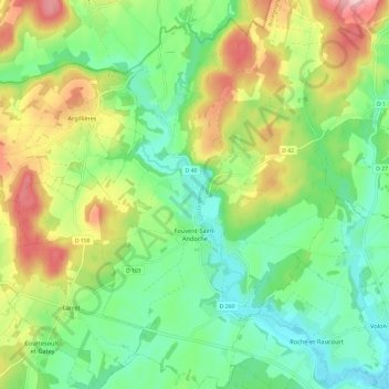
Name: Fouvent-Saint-Andoche topographic map, elevation, terrain.
Average elevation: 271 m
Minimum elevation: 205 m
Maximum elevation: 384 m
Other topographic maps
Click on a map to view its topography, its elevation and its terrain.
Fouvent-le-Bas
Frankrijk > Bourgondië-Franche-Comté > Haute-Saône > Fouvent-Saint-Andoche > Fouvent-le-Bas
Fouvent-le-Bas, Fouvent-Saint-Andoche, Vesoul, Haute-Saône, Bourgondië-Franche-Comté, Metropolitaans Frankrijk, Frankrijk
Average elevation: 269 m