
Thank you for supporting this site ❤️
Make a donation
Make a donation
Baiyin topographic map
Click on the map to display elevation.
Thank you for supporting this site ❤️
Make a donation
Make a donation
Baiyin
Baiyin is part loess plateau, part desert. Elevation ranges from 1,275 to 3,321 meters (4,183 to 10,896 feet) above sea-level. The climate is very arid with only 110–352 mm (4.3–13.9 in) of annual precipitation. Annual evaporation is 2,101 mm (82.7 in) resulting in a net loss of approximately 1,800 mm (71 in). The Yellow River flows from south to north for 214 km (133 mi) through Baiyin.
Thank you for supporting this site ❤️
Make a donation
Make a donation
About this map
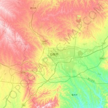
Name: Baiyin topographic map, elevation, terrain.
Location: Baiyin, Baiyin District, Baiyin City, Gansu, China (36.38516 103.97554 36.70516 104.29554)
Average elevation: 1,836 m
Minimum elevation: 1,460 m
Maximum elevation: 2,239 m
Thank you for supporting this site ❤️
Make a donation
Make a donation