
Buchs (SG) topographic map
Interactive map
Click on the map to display elevation.
About this map
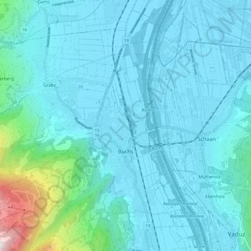
Name: Buchs (SG) topographic map, elevation, terrain.
Location: Buchs (SG), Wahlkreis Werdenberg, Saint-Gall, Suisse (47.13703 9.39773 47.20304 9.50265)
Average elevation: 576 m
Minimum elevation: 436 m
Maximum elevation: 1,715 m
Selon l'Office fédéral de la statistique, le territoire communal mesure 15,95 km2. Le point le plus bas est au niveau du fleuve, à 441 mètres d’altitude. Le point culminant est au sommet du Glannachopf, à 2 232 mètres d’altitude.
Other topographic maps
Click on a map to view its topography, its elevation and its terrain.
Gams
Suisse > Saint-Gall > Wahlkreis Werdenberg
Gams, Wahlkreis Werdenberg, Saint-Gall, 9473, Suisse
Average elevation: 789 m
Grabs
Suisse > Saint-Gall > Wahlkreis Werdenberg > Grabs
Grabs, Wahlkreis Werdenberg, Saint-Gall, 9472, Suisse
Average elevation: 916 m
Oberschan
Suisse > Saint-Gall > Wahlkreis Werdenberg > Wartau
Oberschan, Wartau, Wahlkreis Werdenberg, Saint-Gall, 9479, Suisse
Average elevation: 753 m
Wartau
Suisse > Saint-Gall > Wahlkreis Werdenberg
Wartau, Wahlkreis Werdenberg, Saint-Gall, Suisse
Average elevation: 950 m