
Imphal East topographic map
Interactive map
Click on the map to display elevation.
About this map
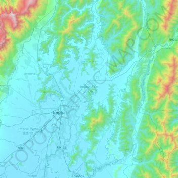
Name: Imphal East topographic map, elevation, terrain.
Location: Imphal East, Manipur, India (24.65151 93.89542 25.05120 94.13485)
Average elevation: 982 m
Minimum elevation: 767 m
Maximum elevation: 2,498 m
Imphal East District came into existence on 18-06-1997 with its headquarters at Porompat occupying the eastern part of Imphal District. The total area of District is 497 km2. approximately. The District is situated at an altitude 790 metres above the M.S. Level. The climate of the District is salubrious and Monsoon is tropical. The minimum temperature goes down to 0.6 degree Celsius in winter and 41 degree Celsius in summer. It has no rail network and hence communication is entirely dependent on roads except Jiribam District bordering Cachar District of Assam where there is a railhead. As of 2017, A new rail line is under construction and a railway station will be operational by 2019. The District is connected with N.H. 39, N.H. 53 and N.H. 150.
Other topographic maps
Click on a map to view its topography, its elevation and its terrain.
Leimakhong
India > Manipur > Saitu-Gamphazol
Leimakhong, Saitu-Gamphazol, Kangpokpi District, Manipur, 795136, India
Average elevation: 967 m
Koubru
India > Manipur > Saitu-Gamphazol
Koubru, Saitu-Gamphazol, Kangpokpi, Manipur, India
Average elevation: 2,146 m
Imphal
India > Manipur > Lamphelpat
Imphal, Lamphelpat, Imphal West District, Manipur, 795001, India
Average elevation: 861 m
Iril River
Iril River, Sawombung, Imphal East, Manipur, 795118, India
Average elevation: 992 m
Manipur River
India > Manipur > Chakpikarong
Manipur River, Chakpikarong, Chandel, Manipur, India
Average elevation: 964 m
Khuga Dam
India > Manipur > Churachandpur
Khuga Dam, Churachandpur, Manipur, India
Average elevation: 849 m
Lamphelpat
India > Manipur > Lamphelpat
Lamphelpat, Imphal West, Manipur, 795002, India
Average elevation: 828 m
Nambul River
Nambul River, Imphal, Lamphelpat, Imphal West, Manipur, 795001, India
Average elevation: 784 m
Singda Dam
Singda Dam, Saitu-Gamphazol, Kangpokpi, Manipur, India
Average elevation: 948 m
Loktak Lake
India > Manipur > Nambol block > Karang
Loktak Lake, Karang, Nambol block, Bishnupur District, Manipur, India
Average elevation: 771 m