
Bous-Waldbredimus topographic map
Interactive map
Click on the map to display elevation.
About this map
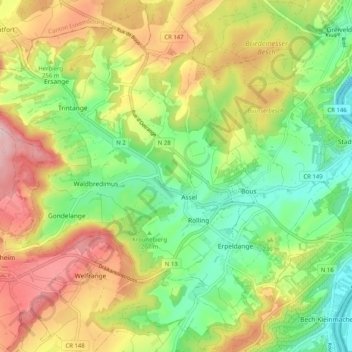
Name: Bous-Waldbredimus topographic map, elevation, terrain.
Location: Bous-Waldbredimus, Canton Remich, Luxembourg (49.53048 6.25377 49.58656 6.35538)
Average elevation: 236 m
Minimum elevation: 131 m
Maximum elevation: 373 m
Other topographic maps
Click on a map to view its topography, its elevation and its terrain.
Greiveldange
Greiveldange, Stadtbredimus, Canton Remich, 5426, Luxembourg
Average elevation: 211 m
Emeringerhaff
Luxembourg > Canton Remich > Bous-Waldbredimus > Erpeldange
Emeringerhaff, Erpeldange, Bous-Waldbredimus, Canton Remich, 5422, Luxembourg
Average elevation: 208 m