
Ladysmith topographic map
Click on the map to display elevation.
About this map
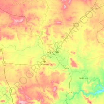
Name: Ladysmith topographic map, elevation, terrain.
Average elevation: 1,095 m
Minimum elevation: 792 m
Maximum elevation: 1,439 m
Other topographic maps
Click on a map to view its topography, its elevation and its terrain.
Spioenkop Dam
South Africa > KwaZulu-Natal > Uthukela District Municipality > Okhahlamba Local Municipality
Average elevation: 1,139 m
Umtshezi Ward 5
South Africa > KwaZulu-Natal > Uthukela District Municipality > Umtshezi Local Municipality
Average elevation: 930 m
Okhahlamba Ward 6
South Africa > KwaZulu-Natal > Uthukela District Municipality > Okhahlamba Local Municipality
Average elevation: 1,903 m
Woodstock Dam
South Africa > KwaZulu-Natal > Uthukela District Municipality > Okhahlamba Local Municipality
Average elevation: 1,192 m
Okhahlamba Ward 4
South Africa > KwaZulu-Natal > Uthukela District Municipality > Okhahlamba Local Municipality
Average elevation: 1,378 m
Emnambithi/Ladysmith Local Municipality
South Africa > KwaZulu-Natal > Uthukela District Municipality
Average elevation: 1,244 m
Wasbank
South Africa > KwaZulu-Natal > Uthukela District Municipality > Indaka Local Municipality
Average elevation: 1,071 m
Okhahlamba Local Municipality
South Africa > KwaZulu-Natal > Uthukela District Municipality
Average elevation: 1,584 m
Umtshezi
South Africa > KwaZulu-Natal > Uthukela District Municipality > Imbabazane Local Municipality
Average elevation: 2,130 m
Indaka Local Municipality
South Africa > KwaZulu-Natal > Uthukela District Municipality
Average elevation: 1,016 m
Okhahlamba Local Municipality
South Africa > KwaZulu-Natal > Uthukela District Municipality
Average elevation: 1,584 m
Okhahlamba Local Municipality
South Africa > KwaZulu-Natal > Uthukela District Municipality
Average elevation: 1,584 m
Spioenkop Dam
South Africa > KwaZulu-Natal > Uthukela District Municipality > Okhahlamba Local Municipality
Average elevation: 1,139 m
Emnambithi/Ladysmith Ward 13
South Africa > KwaZulu-Natal > Uthukela District Municipality > Emnambithi/Ladysmith Local Municipality
Average elevation: 1,106 m
Okhahlamba Local Municipality
South Africa > KwaZulu-Natal > Uthukela District Municipality
Average elevation: 1,584 m