
Thank you for supporting this site ❤️
Make a donation
Make a donation
Pulau Sanglang Besar topographic map
Click on the map to display elevation.
Thank you for supporting this site ❤️
Make a donation
Make a donation
About this map
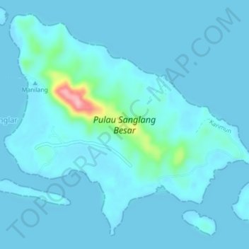
Name: Pulau Sanglang Besar topographic map, elevation, terrain.
Location: Pulau Sanglang Besar, Karimun, Riau Islands, Indonesia (0.60439 103.67086 0.63640 103.70681)
Average elevation: 11 m
Minimum elevation: 0 m
Maximum elevation: 143 m
Thank you for supporting this site ❤️
Make a donation
Make a donation
Other topographic maps
Click on a map to view its topography, its elevation and its terrain.