
Make a donation
Benguela Province topographic map
Click on the map to display elevation.
Make a donation
Benguela Province
Benguela Province is situated in the west of the country, on the Atlantic coast. It also borders the provinces of Cuanza Sul (to the north), Namibe (to the southwest), Huila (to the southeast), and Huambo (to the east). It is traversed by the northwesterly line of equal latitude and longitude with three zones: coastal at 0–500 metres (0–1,640 ft); central at 500–1,200 metres (1,600–3,900 ft); and eastern with a medium altitude greater than 1,500 metres (4,900 ft).
Make a donation
About this map
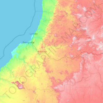
Name: Benguela Province topographic map, elevation, terrain.
Location: Benguela Province, Angola (-13.88838 12.31596 -11.75892 15.11083)
Average elevation: 888 m
Minimum elevation: 0 m
Maximum elevation: 2,541 m
Make a donation
Other topographic maps
Click on a map to view its topography, its elevation and its terrain.