
Isla de Culebra topographic map
Interactive map
Click on the map to display elevation.
About this map
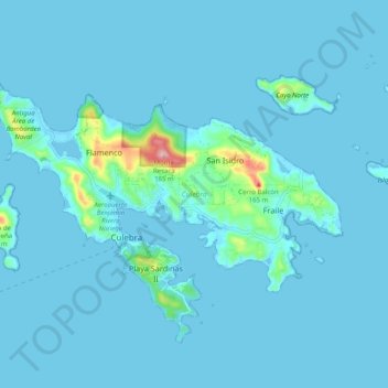
Name: Isla de Culebra topographic map, elevation, terrain.
Location: Isla de Culebra, Culebra, Puerto Rico, USA (18.27709 -65.34430 18.35023 -65.24421)
Average elevation: 11 m
Minimum elevation: -3 m
Maximum elevation: 188 m
Other topographic maps
Click on a map to view its topography, its elevation and its terrain.
El Yunque National Forest
El Yunque National Forest, Calle Maga, Villa Sin Miedo, Lomas, Canóvanas, Puerto Rico, 00777, USA
Average elevation: 376 m
Tortugo
USA > Puerto Rico > Río Piedras
Tortugo, Río Piedras, San Juan, Puerto Rico, USA
Average elevation: 89 m