
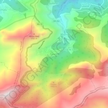
Tirourda topographic map
Interactive map
Click on the map to display elevation.
About this map
Name: Tirourda topographic map, elevation, terrain.
Average elevation: 1,345 m
Minimum elevation: 774 m
Maximum elevation: 1,936 m
Other topographic maps
Click on a map to view its topography, its elevation and its terrain.
Laâzib Aït Ali
Algérie > Tizi Ouzou > Daïra Iferhounene > Iferhounene
Laâzib Aït Ali, Iferhounene, Daïra Iferhounene, Tizi Ouzou, 15013, Algérie
Average elevation: 996 m
Ait Anzar
Algérie > Tizi Ouzou > Daïra Iferhounene > Iferhounene
Ait Anzar, Iferhounene, Daïra Iferhounene, Tizi Ouzou, 15024, Algérie
Average elevation: 934 m
Bouaidel
Algérie > Tizi Ouzou > Daïra Iferhounene > Iferhounene
Bouaidel, Iferhounene, Daïra Iferhounene, Tizi Ouzou, 15037, Algérie
Average elevation: 795 m
Tiruda
Algérie > Tizi Ouzou > Daïra Iferhounene > Iferhounene
Tiruda, Iferhounene, Daïra Iferhounene, Tizi Ouzou, Algérie
Average elevation: 1,471 m
Bechar
Algérie > Tizi Ouzou > Daïra Iferhounene > Iferhounene > Bechar
Bechar, Iferhounene, Daïra Iferhounene, Tizi Ouzou, 15024, Algérie
Average elevation: 959 m