Geolocate

South Sinai topographic map

Interactive map

Click on the map to display elevation.

About this map

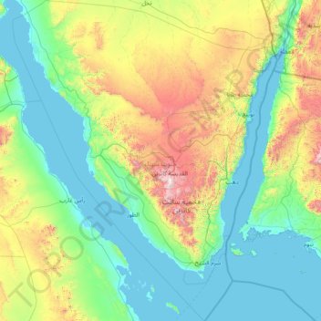
Name: South Sinai topographic map, elevation, terrain.

Location: South Sinai, Egypt (27.38831 32.53976 29.92325 34.92121)

Average elevation: 432 m

Minimum elevation: -2 m

Maximum elevation: 2,496 m

Other topographic maps

Click on a map to view its topography, its elevation and its terrain.

Giza

Egypt > Giza

Average elevation: 72 m

10th of Ramadan

Egypt > Eastern

Average elevation: 104 m

Northern Oases

Egypt > Giza

Average elevation: 170 m

North Sinai Governorate

Egypt

Average elevation: 353 m

Tizmant East Village

Egypt > Bani Sweif

Average elevation: 30 m

Al Minya

Egypt > Al Minya

Average elevation: 83 m

Mudiriyat al Gharbiyah

Egypt > Seberbay

Average elevation: 46 m

Luxor City

Egypt > Luxor

Average elevation: 78 m

Ouseem

Egypt > Giza Governorate > Ouseem

Average elevation: 17 m

Ismailia Governorate

Egypt

Average elevation: 188 m

St Catherine

Egypt > South Sinai > St Catherine

Average elevation: 1,472 m