
Thank you for supporting this site ❤️
Make a donation
Make a donation
Cavendish topographic map
Click on the map to display elevation.
Thank you for supporting this site ❤️
Make a donation
Make a donation
About this map
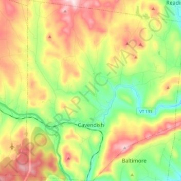
Name: Cavendish topographic map, elevation, terrain.
Location: Cavendish, Windsor County, Vermont, United States (43.34814 -72.66247 43.45710 -72.53026)
Average elevation: 393 m
Minimum elevation: 192 m
Maximum elevation: 648 m
Thank you for supporting this site ❤️
Make a donation
Make a donation
Other topographic maps
Click on a map to view its topography, its elevation and its terrain.
Thank you for supporting this site ❤️
Make a donation
Make a donation
Thank you for supporting this site ❤️
Make a donation
Make a donation
Thank you for supporting this site ❤️
Make a donation
Make a donation
Thank you for supporting this site ❤️
Make a donation
Make a donation
Thank you for supporting this site ❤️
Make a donation
Make a donation