
Make a donation
Scotland topographic map
Click on the map to display elevation.
Make a donation
Scotland
A significant exception to the above are the fossil-bearing beds of Old Red Sandstones found principally along the Moray Firth coast. The Highlands are generally mountainous and the highest elevations in the British Isles are found here. Scotland has over 790 islands divided into four main groups: Shetland, Orkney, and the Inner Hebrides and Outer Hebrides. There are numerous bodies of freshwater including Loch Lomond and Loch Ness. Some parts of the coastline consist of machair, a low-lying dune pasture land.
Make a donation
About this map
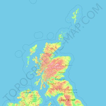
Name: Scotland topographic map, elevation, terrain.
Location: Scotland, United Kingdom (54.43398 -14.01552 61.06100 -0.32092)
Average elevation: 36 m
Minimum elevation: 0 m
Maximum elevation: 1,259 m
Make a donation
Other topographic maps
Click on a map to view its topography, its elevation and its terrain.
Dundee
United Kingdom > Scotland > Dundee City
Dundee sits on the north bank of the Firth of Tay on the eastern, North Sea Coast of Scotland. The city lies 36.1 miles (58 km) NNE of Edinburgh and 360.6 miles (580 km) NNW of London. The built-up area occupies a roughly rectangular shape 8.3 miles (13 km) long by 2.5 miles (4 km) wide, aligned in an east to…
Average elevation: 82 m
Edinburgh
United Kingdom > Scotland > Edinburgh
Some have called Edinburgh the Athens of the North for a variety of reasons. The earliest comparison between the two cities showed that they had a similar topography, with the Castle Rock of Edinburgh performing a similar role to the Athenian Acropolis. Both of them had flatter, fertile agricultural land…
Average elevation: 104 m
Glasgow
United Kingdom > Scotland > Glasgow City
Glasgow itself was reputed to have been founded by the Christian missionary Saint Mungo in the 6th century. He established a church on the Molendinar Burn, where the present Glasgow Cathedral stands, and in the following years Glasgow became a religious centre. Glasgow grew over the following centuries. The…
Average elevation: 128 m
Make a donation
United Kingdom
Scotland accounts for just under a third (32 per cent) of the total area of the UK, covering 78,772 square kilometres (30,410 sq mi). This includes nearly eight hundred islands, predominantly west and north of the mainland; notably the Hebrides, Orkney Islands and Shetland Islands. Scotland is the most…
Average elevation: 79 m
Cambridge
United Kingdom > England > Cambridge
The city, like most of the UK, has a maritime climate highly influenced by the Gulf Stream. Located in the driest region of Britain, Cambridge's rainfall averages around 570 mm (22.44 in) per year, around half the national average, with some years occasionally falling into the semi-arid (under 500 mm (19.69…
Average elevation: 18 m
Make a donation
Leeds
Lying in the eastern foothills of the Pennines, there is a significant variation in elevation within the city's built-up area. The district ranges from 1,115 feet (340 m) in the far west on the slopes of Ilkley Moor to about 33 feet (10 m) where the rivers Aire and Wharfe cross the eastern boundary. Land rises…
Average elevation: 94 m
Ben Nevis
United Kingdom > Scotland > Highland
Ben Nevis has a highland (alpine) maritime (oceanic) polar climate (ET climate in the Köppen classification). Ben Nevis's elevation, maritime location and topography frequently lead to cool and cloudy weather conditions, which can pose a danger to ill-equipped walkers. According to the observations carried…
Average elevation: 912 m
Newark on Trent
United Kingdom > England > Nottinghamshire > Newark and Sherwood
Average elevation: 18 m
Make a donation
Make a donation
St Albans
United Kingdom > England > Hertfordshire > St Albans
St Albans was an ancient borough created following the dissolution of the monastery in 1539. It consisted of the ancient parish of St Albans (also known as the Abbey parish) and parts of St Michael and St Peter. The municipal corporation was reformed by the Municipal Corporations Act 1835 and the boundary was…
Average elevation: 100 m
Make a donation
Reading
United Kingdom > England > Reading
Mary Russell Mitford lived in Reading for a number of years and then spent the rest of her life just outside the town at Three Mile Cross and Swallowfield. The fictional Belford Regis of her eponymous novel, first published in 1835, is largely based on Reading. Described with topographical accuracy, it is…
Average elevation: 56 m
Marlcliff
United Kingdom > England > Warwickshire > Stratford-on-Avon > Bidford on Avon CP
Average elevation: 41 m
Make a donation
Make a donation
Make a donation
Ely
United Kingdom > England > Ely
For over 800 years the cathedral and its associated buildings—built on an elevation 68 feet (21 m) above the nearby fens—have visually influenced the city and its surrounding area. Geographer John Jones, writing in 1924, reports that "from the roof of King's Chapel in Cambridge, on a clear day, Ely can be…
Average elevation: 13 m
Swansea
United Kingdom > Wales > Swansea
Much of Swansea is hilly with the main area of upland being located in the council ward of Mawr. Areas up to 185 metres (607 ft) in elevation range across the central section: Kilvey Hill, Townhill and Llwynmawr separate the centre of Swansea from its northern suburbs. Cefn Bryn, a ridge of high land, is the…
Average elevation: 73 m
Make a donation
Swindon
United Kingdom > England > Swindon
Swindon has an oceanic climate (Cfb in the Köppen climate classification), like the vast majority of the British Isles, with cool winters and warm summers. The nearest official weather station is RAF Lyneham, about 10 miles (16 km) west southwest of Swindon town centre. The weather station's elevation is 145…
Average elevation: 108 m
Make a donation
Peterborough
United Kingdom > England > Cambridgeshire
The local topography is flat, and in some places, the land lies below sea level, for example in parts of the Fens to the east and to the south of Peterborough. Human settlement in the area began before the Bronze Age, as can be seen at the Flag Fen archaeological site to the east of the current city centre,…
Average elevation: 17 m
Sgùrr an Utha
United Kingdom > Scotland > Highland
Sgùrr an Utha and Fraoch-bheinn are two hills above Glenfinnan, in Lochaber, Highland, Scotland. The two summits are joined by a summit ridge, which is 735 m above sea level at its lowest elevation. The glen of Glen Finnan itself lies just to the east.
Average elevation: 475 m
Long Holt Wood
United Kingdom > England > Lincolnshire > North Kesteven > Nocton
Average elevation: 20 m
Make a donation
Levisham Moor
United Kingdom > England > North Yorkshire > Newton upon Rawcliffe
Average elevation: 188 m
Make a donation
Make a donation
Snowdon
United Kingdom > Wales > Gwynedd
Snowdon (/ˈsnoʊdən/) or Yr Wyddfa (pronounced [ər ˈʊɨ̞̯ðva] (listen)), is the highest mountain in Wales, at an elevation of 1,085 metres (3,560 ft) above sea level, and the highest point in the British Isles outside the Scottish Highlands. It is located in Snowdonia National Park (Parc Cenedlaethol…
Average elevation: 692 m
Felbridge
United Kingdom > England > West Sussex > Mid Sussex > East Grinstead
Average elevation: 98 m
Make a donation
Cley Hill
United Kingdom > England > Wiltshire
Cley Hill (grid reference ST838449) is a prominent hill to the west of Warminster in Wiltshire, England. Its summit has a commanding view of the Wiltshire / Somerset county boundary, at 244 metres (801 ft) elevation. The land is in Corsley parish and is owned by the National Trust.
Average elevation: 157 m
Scottish Highlands
United Kingdom > Scotland > Highland
The entire region was covered by ice sheets during the Pleistocene ice ages, save perhaps for a few nunataks. The complex geomorphology includes incised valleys and lochs carved by the action of mountain streams and ice, and a topography of irregularly distributed mountains whose summits have similar heights…
Average elevation: 907 m
Make a donation
Portsmouth
United Kingdom > England > Hampshire > Portsmouth
By road, Portsmouth lies 73.5 miles (118.3 km) from Central London, 49.5 miles (79.7 km) west of Brighton, and 22.3 miles (35.9 km) east of Southampton. Portsmouth is situated primarily on Portsea Island and is the United Kingdom's only island city, although parts of it have expanded onto the mainland. Gosport…
Average elevation: 28 m
Hull
United Kingdom > England > Kingston upon Hull
Kingston upon Hull is on the northern bank of the Humber Estuary. The city centre is west of the River Hull and close to the Humber. The city is built upon alluvial and glacial deposits which overlie chalk rocks but the underlying chalk has no influence on the topography. The land within the city is generally…
Average elevation: 21 m
Make a donation
Aberdeen
United Kingdom > Scotland > Aberdeen
Two weather stations collect climate data for the area, Aberdeen/Dyce Airport, and Craibstone. Both are about 4 1⁄2 miles (7 km) to the north west of the city centre, and given that they are in close proximity to each other, exhibit very similar climatic regimes. Dyce tends to have marginally warmer daytime…
Average elevation: 52 m
Blencathra
United Kingdom > England > Westmorland and Furness > Threlkeld
The Northern Fells make up a roughly circular upland area about 10 miles (16 km) wide. At the centre is the marshy depression of Skiddaw Forest — a treeless plateau at an altitude of 1,300 ft (400 m) — and flowing outward from here are the rivers which divide the area into three sectors. Between the…
Average elevation: 577 m
Make a donation
Make a donation
Make a donation
Little Solsbury Hill
United Kingdom > England > Bath and North East Somerset > Batheaston
Average elevation: 88 m
Make a donation
City of London
United Kingdom > England > City of London > City of London
The elevation of the City ranges from sea level at the Thames to 21.6 metres (71 ft) at the junction of High Holborn and Chancery Lane. Two small but notable hills are within the historic core, Ludgate Hill to the west and Cornhill to the east. Between them ran the Walbrook, one of the many "lost" rivers or…
Average elevation: 42 m
Make a donation
Derry/Londonderry
United Kingdom > Northern Ireland > County Londonderry
Derry is characterised by its distinctively hilly topography. The River Foyle forms a deep valley as it flows through the city, making Derry a place of very steep streets and sudden, startling views. The original walled city of Londonderry lies on a hill on the west bank of the River Foyle. In the past, the…
Average elevation: 88 m
Richmond
United Kingdom > England > London
The town centre lies just below 33 ft (10m) above sea level. South of the town centre, rising from Richmond Bridge to an elevation of 165 ft (50m), is Richmond Hill. Just beyond the summit of Richmond Hill is Richmond Park, an area of 2,360 acres (9.55 km2; 3.7 sq mi) of wild heath and woodland originally…
Average elevation: 17 m
Make a donation
Make a donation
Make a donation
Uxbridge
United Kingdom > England > Greater London
Uxbridge lies at a mean elevation of 130 feet (40 m) above mean sea level. Like much of the rest of the UK its climate is generally temperate, with few extremes of temperature or weather.
Average elevation: 44 m
Make a donation