
Thank you for supporting this site ❤️
Make a donation
Make a donation
Buckland topographic map
Click on the map to display elevation.
Thank you for supporting this site ❤️
Make a donation
Make a donation
About this map
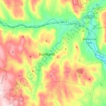
Name: Buckland topographic map, elevation, terrain.
Average elevation: 299 m
Minimum elevation: 89 m
Maximum elevation: 549 m
Thank you for supporting this site ❤️
Make a donation
Make a donation
Other topographic maps
Click on a map to view its topography, its elevation and its terrain.
North Sunderland
United States > Massachusetts > Franklin County > Sunderland
Average elevation: 100 m
Thank you for supporting this site ❤️
Make a donation
Make a donation
Thank you for supporting this site ❤️
Make a donation
Make a donation
Thank you for supporting this site ❤️
Make a donation
Make a donation