
Chumphon topographic map
Interactive map
Click on the map to display elevation.
About this map
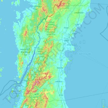
Name: Chumphon topographic map, elevation, terrain.
Location: Chumphon, Thailand (9.60170 98.62871 11.03128 99.76923)
Average elevation: 62 m
Minimum elevation: -3 m
Maximum elevation: 1,036 m
Other topographic maps
Click on a map to view its topography, its elevation and its terrain.
Khao Matsee Viewpoint
Thailand > Chumphon > ปากน้ำชุมพร
Khao Matsee Viewpoint, 4119, ปากน้ำชุมพร, ท่ายาง, Chumphon, Thailand
Average elevation: 8 m