
Make a donation
Malmesbury topographic map
Click on the map to display elevation.
Make a donation
Malmesbury
Malmesbury sits on a flat Cotswolds hilltop at the convergence of two rivers. The town has a maximum elevation of 146 metres (479 ft) and a minimum of 56 metres (184 ft); the average elevation is 92 metres (302 ft) above sea level. From the west, the infant (Bristol) Avon flows from Sherston, and from the north west, a tributary either known as the Tetbury Avon, River Avon (Tetbury branch), or—locally—The Ingleburn. They flow within 200 metres (660 ft) of each other but are separated by a narrow and high isthmus which forces the Bristol Avon south and the Tetbury Avon east. This creates a rocky outcrop as a south-facing, gently sloping hilltop, until the two rivers meet on the southern edge of the town. With steep sides, in places cliff-like, the town was described by Sir William Waller as the best naturally defended inland location he had seen.
Make a donation
About this map
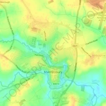
Name: Malmesbury topographic map, elevation, terrain.
Location: Malmesbury, Wiltshire, England, United Kingdom (51.57959 -2.11854 51.59894 -2.08844)
Average elevation: 84 m
Minimum elevation: 66 m
Maximum elevation: 98 m
Make a donation
Other topographic maps
Click on a map to view its topography, its elevation and its terrain.
Make a donation
Make a donation
Make a donation
Make a donation
Make a donation
Make a donation
Make a donation
Cley Hill
United Kingdom > England > Wiltshire
Cley Hill (grid reference ST838449) is a prominent hill to the west of Warminster in Wiltshire, England. Its summit has a commanding view of the Wiltshire / Somerset county boundary, at 244 metres (801 ft) elevation. The land is in Corsley parish and is owned by the National Trust.
Average elevation: 157 m
Make a donation
Make a donation
Make a donation
Make a donation
Make a donation
Make a donation
Make a donation
Make a donation
Make a donation
Make a donation
Make a donation
Make a donation
Make a donation
Roche Court Down
United Kingdom > England > Wiltshire > Winterslow > Lopcombe Corner
Average elevation: 128 m
Make a donation
Make a donation
Make a donation
Make a donation
Make a donation