
Budingen topographic map
Interactive map
Click on the map to display elevation.
About this map
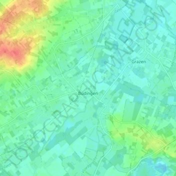
Name: Budingen topographic map, elevation, terrain.
Location: Budingen, Zoutleeuw, Leuven, Vlaams-Brabant, België (50.84612 5.04340 50.88467 5.12009)
Average elevation: 32 m
Minimum elevation: 20 m
Maximum elevation: 68 m
Het dorp ligt in de provincie Vlaams Brabant, aan de samenvloeiing van de Grote en de Kleine Gete op 4,5 km van Zoutleeuw en op 33km van Leuven. Hoogte: 30m aan de kerk en 81m op het hoogste punt.
Other topographic maps
Click on a map to view its topography, its elevation and its terrain.
Zoutleeuw
België > Vlaams-Brabant > Leuven > Zoutleeuw
Zoutleeuw, Leuven, Vlaams-Brabant, Vlaanderen, België
Average elevation: 33 m
Dormaal
België > Vlaams-Brabant > Leuven > Zoutleeuw
Dormaal, Zoutleeuw, Leuven, Vlaams-Brabant, Vlaanderen, België
Average elevation: 46 m