
Uedem topographic map
Interactive map
Click on the map to display elevation.
About this map
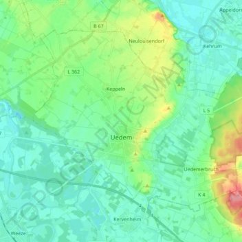
Name: Uedem topographic map, elevation, terrain.
Location: Uedem, Kreis Kleve, North Rhine-Westphalia, 47589, Germany (51.63610 6.21138 51.71523 6.38116)
Average elevation: 31 m
Minimum elevation: 12 m
Maximum elevation: 91 m
Other topographic maps
Click on a map to view its topography, its elevation and its terrain.
Cleves
Germany > North Rhine-Westphalia > Kreis Kleve > Cleves
Cleves, Bedburg-Hau, Kreis Kleve, North Rhine-Westphalia, 47533, Germany
Average elevation: 35 m