
Artuklu topographic map
Interactive map
Click on the map to display elevation.
About this map
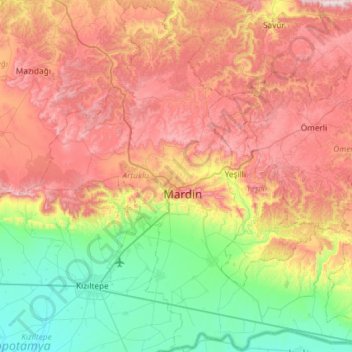
Name: Artuklu topographic map, elevation, terrain.
Location: Artuklu, Mardin, Southeastern Anatolia Region, Turkey (37.10552 40.52689 37.53366 41.07527)
Average elevation: 837 m
Minimum elevation: 441 m
Maximum elevation: 1,298 m
Other topographic maps
Click on a map to view its topography, its elevation and its terrain.
Midyat
Turkey > Southeastern Anatolia Region > Midyat
Midyat, Mardin, Southeastern Anatolia Region, 47500, Turkey
Average elevation: 946 m
Sazgın
Turkey > Southeastern Anatolia Region > Sazgın
Sazgın, Oğuzeli, Gaziantep, Southeastern Anatolia Region, 27920, Turkey
Average elevation: 702 m