
Biotopo Chocón-Machacas topographic map
Interactive map
Click on the map to display elevation.
About this map
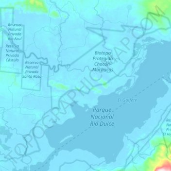
Name: Biotopo Chocón-Machacas topographic map, elevation, terrain.
Location: Biotopo Chocón-Machacas, Livingston, Izabal, Guatemala (15.67726 -88.97394 15.82197 -88.83041)
Average elevation: 19 m
Minimum elevation: -5 m
Maximum elevation: 683 m
Other topographic maps
Click on a map to view its topography, its elevation and its terrain.
Mariscos
Guatemala > Izabal > Los Amates
Mariscos, Los Amates, Izabal, Guatemala
Average elevation: 29 m
Chiriqui
Guatemala > Izabal > Los Amates > Chiriqui
Chiriqui, Los Amates, Izabal, Guatemala
Average elevation: 51 m
Puerto Barrios
Guatemala > Izabal > Puerto Barrios
Puerto Barrios, Izabal, 18013, Guatemala
Average elevation: 92 m
Santo Tomás De Castilla
Guatemala > Izabal > Santo Tomás De Castilla
Santo Tomás De Castilla, Puerto Barrios, Izabal, 18013, Guatemala
Average elevation: 72 m
Los Amates
Guatemala > Izabal > Los Amates > Los Amates
Los Amates, Izabal, Guatemala
Average elevation: 114 m
Río Escondido
Guatemala > Izabal > Puerto Barrios
Río Escondido, Puerto Barrios, Izabal, 18013, Guatemala
Average elevation: 12 m
La Esmeralda
Guatemala > Izabal > La Esmeralda
La Esmeralda, Livingston, Izabal, 18002, Guatemala
Average elevation: 8 m
Laguneta El Amatillo
Laguneta El Amatillo, El Estor, Izabal, Guatemala
Average elevation: 3 m
Balastrera Semox
Guatemala > Izabal > Balastrera Semox
Balastrera Semox, Livingston, Izabal, Guatemala
Average elevation: 59 m