
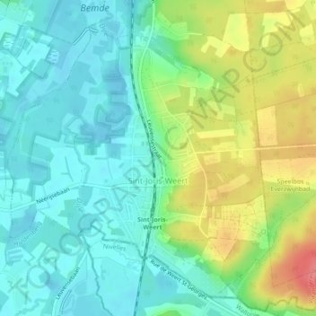
Weert-Saint-Georges topographic map
Interactive map
Click on the map to display elevation.
About this map
Name: Weert-Saint-Georges topographic map, elevation, terrain.
Average elevation: 46 m
Minimum elevation: 22 m
Maximum elevation: 95 m
Other topographic maps
Click on a map to view its topography, its elevation and its terrain.
Haasrode
Belgique > Brabant flamand > Louvain > Vieux-Héverlé > Haasrode
Haasrode, Vieux-Héverlé, Louvain, Brabant flamand, Flandre, 3053, Belgique
Average elevation: 76 m