
Evansville topographic map
Interactive map
Click on the map to display elevation.
About this map
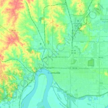
Name: Evansville topographic map, elevation, terrain.
Location: Evansville, Vanderburgh County, Indiana, United States (37.93559 -87.63755 38.05689 -87.44987)
Average elevation: 122 m
Minimum elevation: 105 m
Maximum elevation: 179 m
Other topographic maps
Click on a map to view its topography, its elevation and its terrain.
Darmstadt
United States > Indiana > Vanderburgh County
Darmstadt, Vanderburgh County, Indiana, United States
Average elevation: 143 m
Inglefield
United States > Indiana > Vanderburgh County
Inglefield, Vanderburgh County, Indiana, 47725, United States
Average elevation: 142 m
Evansville
United States > Indiana > Vanderburgh County
Evansville, Vanderburgh County, Indiana, United States
Average elevation: 126 m
Smythe
United States > Indiana > Vanderburgh County > Evansville
Smythe, Evansville, Vanderburgh County, Indiana, 47715, United States
Average elevation: 119 m
Mud Center
United States > Indiana > Vanderburgh County > Evansville > Mud Center
Mud Center, Evansville, Vanderburgh County, Indiana, 47712, United States
Average elevation: 121 m
Saint Joseph
United States > Indiana > Vanderburgh County > Saint Joseph
Saint Joseph, Vanderburgh County, Indiana, 47720, United States
Average elevation: 156 m