
Copper Harbor topographic map
Interactive map
Click on the map to display elevation.
About this map
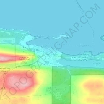
Name: Copper Harbor topographic map, elevation, terrain.
Average elevation: 220 m
Minimum elevation: 177 m
Maximum elevation: 350 m
Other topographic maps
Click on a map to view its topography, its elevation and its terrain.
Eagle Harbor Township
United States > Michigan > Keweenaw County
Eagle Harbor Township, Keweenaw County, Michigan, United States
Average elevation: 190 m
Mohawk
United States > Michigan > Keweenaw County
Mohawk, Allouez Township, Keweenaw County, Michigan, 49901, United States
Average elevation: 300 m
Eagle Harbor
United States > Michigan > Keweenaw County
Eagle Harbor, Eagle Harbor Township, Keweenaw County, Michigan, United States
Average elevation: 200 m
Allouez
United States > Michigan > Keweenaw County
Allouez, Allouez Township, Keweenaw County, Michigan, 49805, United States
Average elevation: 301 m
Isle Royale
United States > Michigan > Keweenaw County
Isle Royale, Keweenaw County, Michigan, United States
Average elevation: 190 m
Isle Royale National Park
United States > Michigan > Keweenaw County
Isle Royale National Park, Keweenaw County, Michigan, United States
Average elevation: 189 m
Gay
United States > Michigan > Keweenaw County > Gay
Gay, Sherman Township, Keweenaw County, Michigan, United States
Average elevation: 188 m