
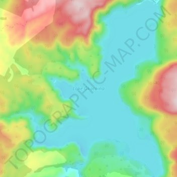
Lake Ōkataina / Te Moana i kataina ā Te Rangitakaroro topographic map
Interactive map
Click on the map to display elevation.
About this map
Name: Lake Ōkataina / Te Moana i kataina ā Te Rangitakaroro topographic map, elevation, terrain.
Average elevation: 440 m
Minimum elevation: 302 m
Maximum elevation: 722 m
Other topographic maps
Click on a map to view its topography, its elevation and its terrain.
Rotorua
New Zealand > Bay of Plenty > Rotorua Lakes District
Rotorua, Rotorua Lakes District, Bay of Plenty, 3010, New Zealand
Average elevation: 435 m
Lake Rotoiti / Te Roto kite ā Ihenga i ariki ai Kahu
New Zealand > Bay of Plenty > Rotorua Lakes District > Okere Falls
Lake Rotoiti / Te Roto kite ā Ihenga i ariki ai Kahu, Okere Falls, Rotorua Lakes District, Bay of Plenty, New Zealand
Average elevation: 375 m
Lake Okaro
New Zealand > Bay of Plenty > Rotorua Lakes District
Lake Okaro, Rotorua Lakes District, Bay of Plenty, New Zealand
Average elevation: 424 m
Hamurana
New Zealand > Bay of Plenty > Rotorua Lakes District
Hamurana, Rotorua Lakes District, Bay of Plenty, 3096, New Zealand
Average elevation: 331 m
Kaingaroa Forest
New Zealand > Bay of Plenty > Rotorua Lakes District
Kaingaroa Forest, Rotorua Lakes District, Bay of Plenty, New Zealand
Average elevation: 521 m
Lake Rotorua
New Zealand > Bay of Plenty > Rotorua Lakes District > Hamurana
Lake Rotorua, Hamurana, Rotorua Lakes District, Bay of Plenty, 3040, New Zealand
Average elevation: 299 m
Ngongotaha
New Zealand > Bay of Plenty > Rotorua Lakes District
Ngongotaha, Rotorua Lakes District, Bay of Plenty, New Zealand
Average elevation: 339 m
Lake Rotomahana
New Zealand > Bay of Plenty > Rotorua Lakes District
Lake Rotomahana, Rotorua Lakes District, Bay of Plenty, New Zealand
Average elevation: 366 m
Lake Tarawera
New Zealand > Bay of Plenty > Rotorua Lakes District > Lake Tarawera
Lake Tarawera, Rotorua Lakes District, Bay of Plenty, New Zealand
Average elevation: 394 m
Lake Okareka
New Zealand > Bay of Plenty > Rotorua Lakes District
Lake Okareka, Rotorua Lakes District, Bay of Plenty, New Zealand
Average elevation: 441 m
Te Ngae
New Zealand > Bay of Plenty > Rotorua Lakes District > Tikitere
Te Ngae, Tikitere, Rotorua Lakes District, Bay of Plenty, New Zealand
Average elevation: 306 m
Lake Rotoehu
New Zealand > Bay of Plenty > Rotorua Lakes District
Lake Rotoehu, Rotorua Lakes District, Bay of Plenty, New Zealand
Average elevation: 325 m
Gisborne Point
New Zealand > Bay of Plenty > Rotorua Lakes District
Gisborne Point, Rotorua Lakes District, Bay of Plenty, New Zealand
Average elevation: 350 m
Lake Rotokakahi
New Zealand > Bay of Plenty > Rotorua Lakes District > Rotorua
Lake Rotokakahi, Rotorua, Rotorua Lakes District, Bay of Plenty, New Zealand
Average elevation: 471 m