
Thank you for supporting this site ❤️
Make a donation
Make a donation
Jiaoling County topographic map
Click on the map to display elevation.
Thank you for supporting this site ❤️
Make a donation
Make a donation
About this map
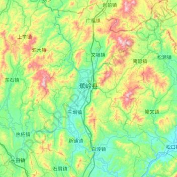
Name: Jiaoling County topographic map, elevation, terrain.
Location: Jiaoling County, Meizhou, Guangdong Province, China (24.42479 116.02233 24.88101 116.41298)
Average elevation: 329 m
Minimum elevation: 53 m
Maximum elevation: 1,106 m
Thank you for supporting this site ❤️
Make a donation
Make a donation
Other topographic maps
Click on a map to view its topography, its elevation and its terrain.