
Thank you for supporting this site ❤️
Make a donation
Make a donation
Niagara Region topographic map
Click on the map to display elevation.
Thank you for supporting this site ❤️
Make a donation
Make a donation
About this map
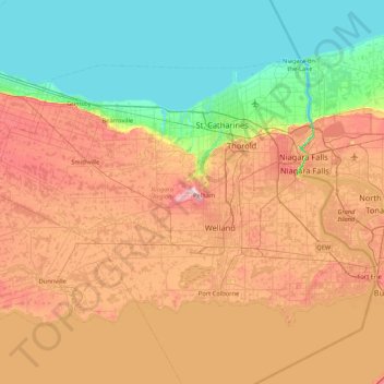
Name: Niagara Region topographic map, elevation, terrain.
Location: Niagara Region, Golden Horseshoe, Ontario, Canada (42.83200 -79.75396 43.26603 -78.90595)
Average elevation: 148 m
Minimum elevation: 72 m
Maximum elevation: 259 m
Thank you for supporting this site ❤️
Make a donation
Make a donation
Other topographic maps
Click on a map to view its topography, its elevation and its terrain.
Maxville
Canada > Ontario > Stormont, Dundas and Glengarry Counties > North Glengarry
Average elevation: 100 m
Thank you for supporting this site ❤️
Make a donation
Make a donation
Thank you for supporting this site ❤️
Make a donation
Make a donation
Tower Island
Canada > Ontario > Kenora District > Unorganized Kenora District
Average elevation: 349 m
Thank you for supporting this site ❤️
Make a donation
Make a donation