
Wiehe topographic map
Interactive map
Click on the map to display elevation.
About this map
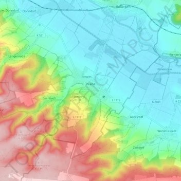
Name: Wiehe topographic map, elevation, terrain.
Location: Wiehe, Roßleben-Wiehe, Kyffhäuserkreis, Thüringen, Duitsland (51.23657 11.34040 51.29093 11.45601)
Average elevation: 196 m
Minimum elevation: 111 m
Maximum elevation: 361 m
Other topographic maps
Click on a map to view its topography, its elevation and its terrain.
Westerengel
Duitsland > Thüringen > Kyffhäuserkreis > Greußen
Westerengel, Greußen, Kyffhäuserland, Kyffhäuserkreis, Thüringen, 99707, Duitsland
Average elevation: 308 m
Das Oberriet
Duitsland > Thüringen > Kyffhäuserkreis > Artern
Das Oberriet, Schönfeld, Artern, Kyffhäuserkreis, Thüringen, 06556, Duitsland
Average elevation: 123 m
Thalebra
Duitsland > Thüringen > Kyffhäuserkreis > Sondershausen
Thalebra, Sondershausen, Kyffhäuserkreis, Thüringen, Duitsland
Average elevation: 282 m
Steinthaleben
Duitsland > Thüringen > Kyffhäuserkreis > Kyffhäuserland
Steinthaleben, Kyffhäuserland, Kyffhäuserkreis, Thüringen, Duitsland
Average elevation: 251 m